Realty Executives of Northern Arizona
New app aims to ease bike route guidance in Flagstaff
SAM MCLAUGHLIN Sun Staff Reporter, Arizona Daily Sun
Sep 3, 2025
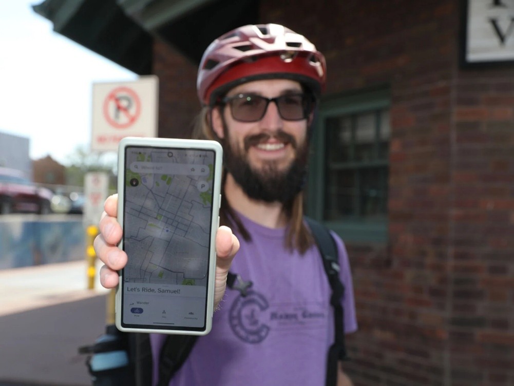
Sam Noble stands in downtown flagstaff at the train station with his Bike Streets app on his phone. The app helps cyclists find low-stress and low-traffic routes to use through cities and towns.
Jake Bacon, Arizona Daily Sun
Looking for a better way to get around Flagstaff by bike? Now there’s an app for that.
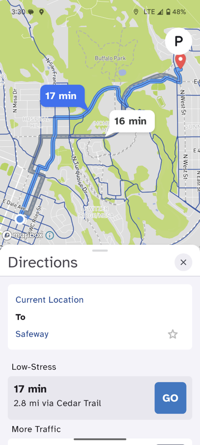
Bike Streets, first launched in Denver, will be available for Flagstaff users beginning Sept. 3. The app’s core feature is its “low-stress” bike map, created and verified by local riders. That map allows the app to suggest routing options based on safety and rider comfort, rather than just the shortest travel time.
“I think a lot of people, when they think of bike routes to and from point A to point B, your brain is immediately going to go to the route that you take via car,” said Sam Noble, who’s been helping build out the Flagstaff map. “And that is not always going to be the best route -- and most often it’s not the best route to go -- if you’re on a bike.”
The low-stress bike map prioritizes quieter roads with less traffic, pathways like the Flagstaff Urban Trail System or protected bike lanes (where available). The goal, according to Noble, is to make the experience of commuting or traveling by bike less intimidating for people who don’t feel comfortable riding in or alongside heavy car traffic and to demonstrate that safe options exist.
Sam Noble, courtesy
“This allows us to use what’s currently on the ground and get people who might be timid or don’t know the routes, to get them out of the house and out of the car,” Noble said.
Avi Stopper, one of the founders and developers of Bike Streets, said he’s come to believe that almost every city possesses “a high-comfort bike network hiding in plain sight.”
“We aren’t suggesting that the infrastructure that exists is perfect, by any stretch of the imagination,” Stopper said.
But by tapping into local “folk knowledge” about which roads are safest, or which trails and paths can provide overlooked connections, he believes the low-stress bike maps can convince more people to make more trips by bike without waiting for a perfect network of dedicated infrastructure to be built.
And in the process, he hopes the app will expand the cycling constituency and generate support for eventual improvements.
“We’re trying to build a movement of people who are already riding, who are pressing local leaders to make the investments to improve the facilities,” Stopper said.
One of the biggest obstacles to making trips by bike easier, he noted, is that cities and towns tend to focus on individual projects rather than thinking about the broader picture of connectivity.
“That is one of the things that has really bedeviled bike infrastructure for decades -- we build isolated bike lanes,” he said.
Noble, similarly, said he’d like to see Flagstaff continue to improve its cycling infrastructure through incremental upgrades, and improve connectivity between different zones of the city.
“The FUTS [Flagstaff Urban Trail System] network in Flagstaff is fantastic, but there are missing gaps in it,” Noble said. “So I’d love to see those filled out a little more.”
The Flagstaff bike map is a collaboration between Bike Streets’ developers and the group Flagstaff Strong Towns, a local chapter of a nonprofit organization that is critical of suburban development patterns in the U.S. and advocates for “a shift on local streets from automobile throughput to safety and wealth creation.”
Zak Skelton, an organizer with Flagstaff Strong Towns, said the map can be a useful tool for identifying areas where a little bit of investment could go a long way.
“Working with Bike Streets and mapping and finding those gaps in service, we can start finding those lynchpin pieces where we can make small changes ... to increase the quality of service for everyone in the community,” Skelton said.
As one example, he cited the sidewalk along Route 66 where the road dives beneath the BNSF railway bridge.
“I see people bike all the time in both directions on that very small sidewalk that’s on the west side of that underpass. That, I would call a gap in service,” Skelton explained.
Skelton is also hopeful that the app could facilitate a different kind of experience for Flagstaff's numerous out-of-town visitors.
“I hear all the time: ‘Well, the tourists come, and they bring their cars, and therefore we need to provide car parking or we need to provide car infrastructure for the tourists.’ And I think Bike Streets would be a great opportunity for someone coming up from Phoenix,” he said.
“Sure, they’ll stay in a hotel or they’ll stay in their Airbnb, but once they get here, maybe they leave their car behind -- wherever that is -- and they can bike downtown to use a local restaurant,” he added. “They can bike onto campus to see a musical. … They can really experience the city at a human scale instead of on a car-based scale.”
The Flagstaff team has also developed a low-stress bike map for the Grand Canyon village at the South Rim in an attempt to encourage visitors there to explore outside of their car.
Zak Skelton, courtesy
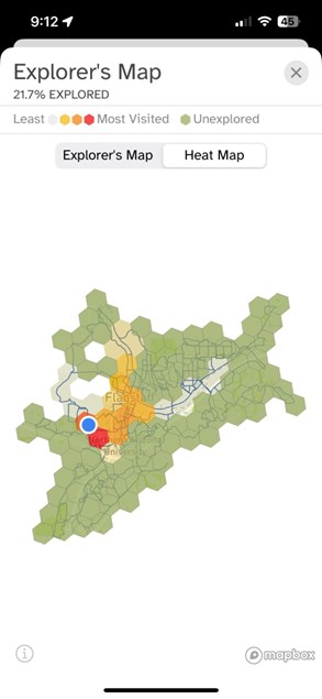
Like many other navigation apps, Bike Streets offers routing and turn-by-turn directions. It also includes an “Explorer’s Map,” which shows what sections of the city a user has or hasn’t visited, and a heat map, which shows a user’s most frequently visited areas. The bike map will also highlight points of interest.
Taken together, Noble and Skelton hope these features will encourage riders to visit new zones and become more familiar with their city.
“I’m riding around on the beta [version] currently, and it has gotten me to take different routes than I would normally take,” Noble said. “So I’ve experienced my city in a different way than I typically would.”
And they recognize that, to keep the map as up-to-date and accurate as possible, user feedback will be important.
“Once we are live, and it’s open to the public, there will be opportunities to submit suggestions or recommendations or issues with the app,” Noble said. “That way it can constantly be evolving.”
The Denver low-stress bike map has gone through thousands of incremental revisions, Stopper said, as more and more users contribute their insights.
“There’s this magic that happens when you have a lot of people riding bikes on the same streets,” Stopped added. “And that magic is sort of a feeling of strength in numbers. You can feel the joy just flowing around.
Stopped added: What we are trying to create is a community-organizing tool, in its essence, that gets people on the same page and riding on the same streets.”
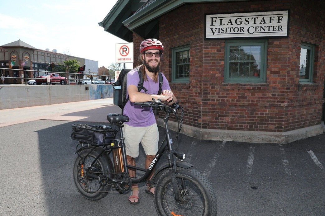
Jake Bacon, Arizona Daily Sun
Bike Streets is available for download through the Apple App Store or the Google Play Store. More information is available at bikestreets.com.
Where the Experts are - Serving Flagstaff and Northern Arizona since 1977
 |
|