Realty Executives of Northern Arizona
If you’ve ever fallen for a neighborhood before you even set foot in a house, you’re not alone.
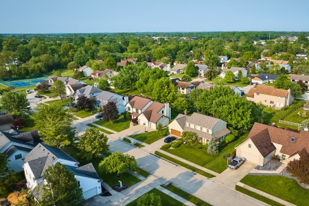
Spend ten minutes on a tree-lined block, and you can almost see your morning routine unfold. Hear a lively café, and you start picturing Friday nights.
That pull matters. Neighborhood choice quietly shapes:
And while we talk a lot about square footage and quartz counters, the biggest decision often happens outside the front door.
To understand the psychology behind why buyers choose one neighborhood over another, read on.
Understanding Buyer Psychology
Homebuyer psychology looks at how people make purchase decisions- not to mention the shortcuts and emotions influencing those choices. In real estate, that means the subtle forces that steer someone toward one neighborhood and away from another…even when the homes look similar on paper.
Cognitive biases appear constantly. Confirmation bias nudges us to notice only the details that match our initial impression of an area and to ignore those that don’t.
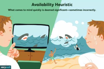
The availability heuristic makes a recent news story about crime feel more representative than long-term data really shows because it’s easy to recall. Loss aversion can spark “fear of missing out” in hot markets, pushing buyers to stretch for a place simply because others want it.
Underneath all of that sits Maslow’s hierarchy of needs. We start
with safety and stability. Then we look for a sense of belonging and esteem. And when we can, we reach for meaning and growth. (Credit: Illustration by Emily Roberts, Verywell)
In neighborhood terms, that might mean gravitating to places that feel safe, connected, or aligned with our identity. Buyers often evaluate neighborhoods based on how they remind them of (let’s say) positive childhood experiences or represent their aspirational identity.
For instance, a young professional might gravitate toward urban lofts. Why? Because they associate that environment with success and sophistication. Meanwhile, a growing family seeks tree-lined streets. Why? That echoes their own upbringing.
Key Factors for Neighborhood Selection
There are key factors that compel people to choose a particular neighborhood over another. Heed our advice: psychology is involved! That said, here’s what homebuyers usually consider:
We all look for clues we’ll fit in. It’s natural to scan for strollers or skateboards and pickup games or poetry nights and think, “these are my people.”
Social identity theory calls this mirroring. When we see bits of ourselves reflected in a community, the place feels more welcoming and less risky.
People naturally seek neighborhoods where they see themselves reflected, whether that’s through shared interests or common values.
For example, neighborhoods with active community gardens appeal to environmentally conscious buyers. Meanwhile, areas with strong youth sports programs draw families who prioritize those activities. This isn’t about labels. It’s about daily rhythms.
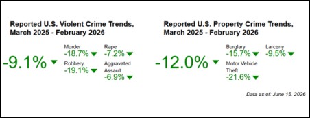
Perceived safety anchors decision-making. Buyers scan crime rates, lighting, foot traffic, and even how well-maintained the sidewalks look. It’s not just rational, it’s primal. Our brains prioritize environments that allow us to relax.
Data helps here. You can explore official statistics in the FBI’s Crime Data Explorer. Many cities publish neighborhood-level reports.
Schools also feed that sense of security. Sandra Black’s influential study found higher test scores measurably boost nearby property values, all else equal.
Buyers often use third-party school resources to start their research. Then, they follow up with visits and conversations. (Source: FBI Crime Data Explorer)
Shorter trips mean more life between trips. The average one-way commute in the U.S. hit 27.6 minutes before the pandemic. The longest on record at the time.
That’s nearly an hour a day. It’s no surprise why proximity to work, childcare, groceries, and parks appear as a must-have for many buyers.
Lifestyle alignment matters, too. Some people thrive on the energy of city blocks and late-night ramen. Others exhale when they reach a quiet cul-de-sac at dusk.
The rise of hybrid and remote work shifted those priorities again:
Many buyers now trade shorter commutes for bigger yards or trail access. Meanwhile, others double down on walkable, amenity-rich hubs.
Clean streets, consistent architecture, cared-for public spaces, and green environments tell our brains a neighborhood is stable and loved.
Research continues to link access to urban green space with lower stress and better mental health. The World Health Organization (WHO) summarizes the benefits of urban green spaces for health– from increased physical activity to improved social connection.
Walkability also has a measurable pull. Higher walk scores correlate with higher home values in many markets. Even after accounting for the home’s size and age. This makes sense. Walking to coffee or a corner store turns errands into micro-adventures, and we tend to pay for that daily delight.
Most buyers build a mental map online before they ever lace up their shoes. Social media turns local coffee shops into mini billboards. Neighborhood forums surface both gems and gripes. And proptech tools like AI-powered property valuation make invisible things visible.
For example, someone researching health and fitness topics online may seek neighborhoods with easy access to healthcare services and wellness clinics. Online tools and data can help buyers quickly identify areas that fit their needs.
Further, virtual neighborhood tours and heat maps showing everything from walkability scores to coffee shop density give buyers unprecedented insight before they ever visit in person. These tools help buyers validate their emotional reactions with concrete data.
Affordability sets the stage for everything else. Monitoring mortgage rates, property taxes, homeowner’s insurance, and HOA dues all shape a buyer’s map.
When rates rise, buyers often broaden their search or adjust their feature preferences. When rates fall, urgency can creep in. The Freddie Mac Primary Mortgage Market Survey provides weekly rate data.
Market mood plays with our heads, too. In a hot cycle, bidding wars can trigger herd behavior and the sense that “everyone wants in here, so should I.” In slower markets, the same block might feel “less desirable,” even when nothing about daily life there changed.
Long-term fundamentals still matter, like property values and neighborhood resilience over time. The FHFA House Price Index tracks price movements across regions.
The Bottom Line
Neighborhood decisions run on a blend of heart and head. We look for safety and stability, but we also chase identity and belonging. Small daily joys like strolling to coffee or waving to the same dog walker each evening make a difference. The trick is to notice those pulls, then sanity-check them with data and on-the-ground visits.
If you’re shopping now, pause and ask: What does a great weekday look like here? What tradeoffs am I making on purpose? Which of my assumptions need a reality check?
When you balance psychology with practical facts, you’ll pick a place that fits not just your budget, but your life.
About the Author: David Abraham is an accomplished tech lawyer and legal marketing expert with a robust background in artificial intelligence, fintech, human rights law, and digital marketing. An active sports enthusiast, avid reader, and chess player, David combines his legal expertise with marketing acumen to drive innovation at the intersection of law, tech, and business.
~Realty Executives International, Alysia Heun
In the coming months, we will bring the different neighborhoods around Flagstaff into focus. Check back to learn more about our lovely northern Arizona!

A midlife move isn’t about escape. It’s about alignment — reshaping your surroundings to match who you’ve become.
The Gist
Moving in midlife is one of the most underrated ways to reinvent your life. It’s a strategic reset that blends practicality with possibility — a chance to redefine your lifestyle, reframe your career, and rediscover your sense of purpose.
Why Moving in Midlife Can Be the Smartest Risk You’ll Ever Take
By your 40s or 50s, you’ve already climbed, achieved, and endured enough to know what you don’t want. A midlife move gives you the freedom to design life on your terms.
Here’s what makes it powerful:
Change has a way of shaking loose the parts of you that have gone quiet. New streets to walk, new neighbors to meet, new opportunities to chase — all of it fuels energy you forgot you had.
Finding the Right Place for the Person You’re Becoming
The “perfect home” at 30 might not fit the life you want at 50. The right neighborhood now is the one that supports your next season — your health, your interests, and your evolving values.
|
What to Think About |
Why It Matters |
Smart Move |
|
Walkability: |
Keeps you active and connected |
Check Walk Score before you move |
|
Community Vibe: |
You need neighbors, not just an address |
Look on Nextdoor or visit a local event |
|
Healthcare Access: |
Health becomes non-negotiable |
Use Zocdoc to preview nearby providers |
|
Culture & Energy: |
You’ll absorb your surroundings |
Read local publications, not tourist blogs |
|
Affordability: |
Stress-free living beats luxury |
Compare costs on Numbeo |
|
Career Opportunities: |
Your move might double as a pivot |
Explore jobs on LinkedIn |
Think of it this way: your home isn’t just where you live — it’s how you live.
Reinventing Your Career: Learning for Your Next Chapter
A new zip code or neighborhood can come with a new identity — and sometimes, a new skill set. Many midlife movers go back to school not to start over but to elevate what they already know.
If you’re already in healthcare, for instance, expanding your education can open leadership or teaching roles. Nurses can enhance their careers and improve patient outcomes by earning an online RN-to-BSN degree (check this out).
The beauty of online learning is freedom: you can keep your job, care for your family, and still level up your career — from your kitchen table or your new home office.
How to Make the Leap Without Losing Your Mind
Questions Everyone Asks (and What They’re Really About)

Only if you believe that standing still is safer. Midlife moves can be calculated, not chaotic — the product of wisdom, not whim.
How will I know it’s time?
When your daily life feels too small for your dreams — that’s the signal.
Something Worth Packing: Smart Storage for New Spaces
If your next move involves simplifying, the Yamazaki Home Tower Storage System is a small-space lifesaver. Its modular design keeps your essentials organized without adding clutter — sleek, functional, and built for reinvention.
The New Frontier of Midlife
A midlife move is not about starting over. It’s about starting right.
You’ve done the building. Now comes the designing — of your home, your days, your second act.
Pack with intention, move with purpose, and remember: the future isn’t waiting for permission. It’s waiting for your address change.
Our experts are here to help you through this reset process. Come by or call to speak to a helpful professional Realtor® today!
When it comes to celebrating the Fourth of July in Arizona, few destinations offer a more memorable experience than Flagstaff. Nestled at 7,000 feet among the world's largest Ponderosa pine forest, Flagstaff combines cool mountain weather, patriotic traditions, family-friendly events, and stunning natural beauty for a truly unique Independence Day celebration.
Whether you're a local resident or planning a weekend getaway, here's what you can expect during Flagstaff's 2026 Fourth of July festivities.
Unlike many Arizona communities that battle triple-digit temperatures in July, Flagstaff typically enjoys daytime highs in the low-to-mid 80s and cool evenings in the 50s, making outdoor celebrations comfortable and enjoyable. The city's charming historic downtown serves as the backdrop for one of Northern Arizona's most beloved holiday celebrations.
The annual Independence Day Parade remains one of the community's signature events. It is believed the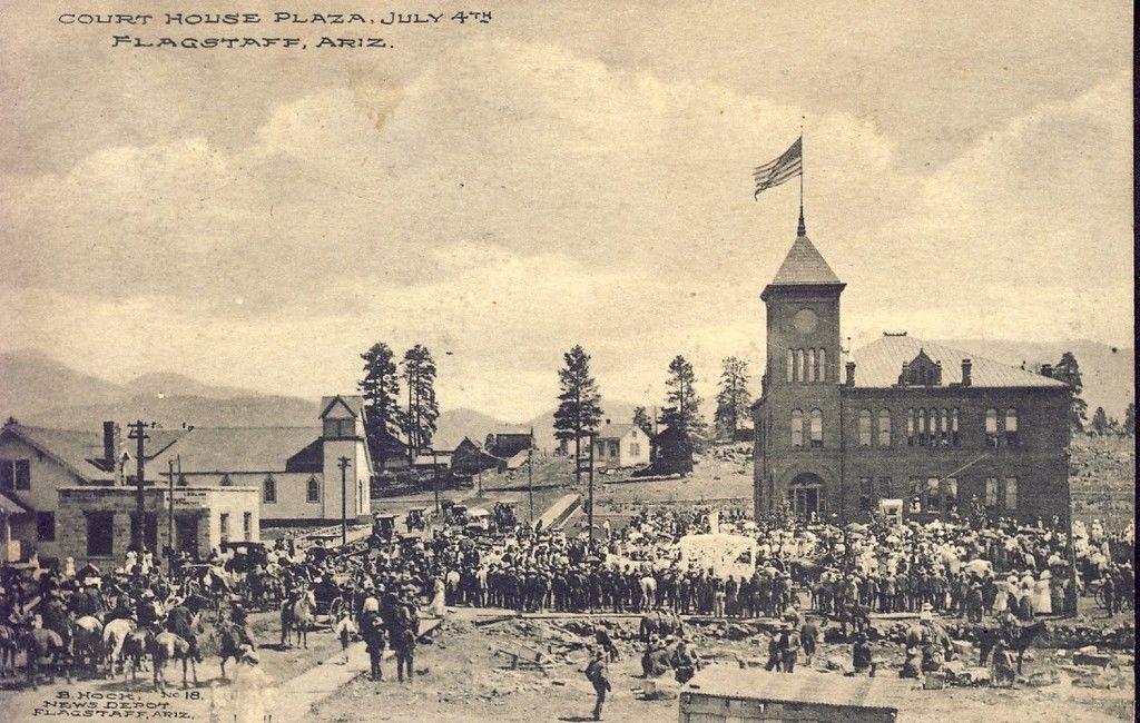

For active participants, the 4th of July Flagstaff Downtown Mile offers a fun way to start the holiday. Presented by Team Run Flagstaff, the event features multiple race divisions, including elite runners, citizen races, masters categories, and a kids' race. The course follows portions of the downtown parade route, creating an energetic atmosphere before the parade begins.
The festive activities continue with one of Flagstaff's most popular summer traditions: Art in the Park returns July 3-5, 2026, at Wheeler Park in downtown Flagstaff. Visitors can browse handcrafted artwork, shop from local artisans, enjoy live music, and sample food from regional vendors. It's an excellent opportunity to support local artists while experiencing the vibrant culture that makes Flagstaff unique.
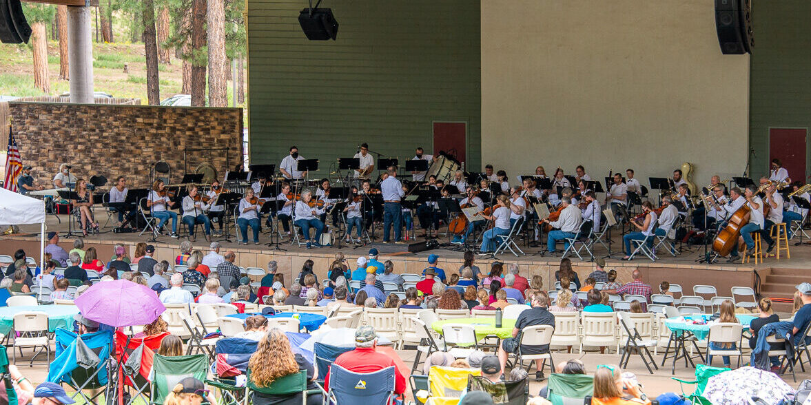
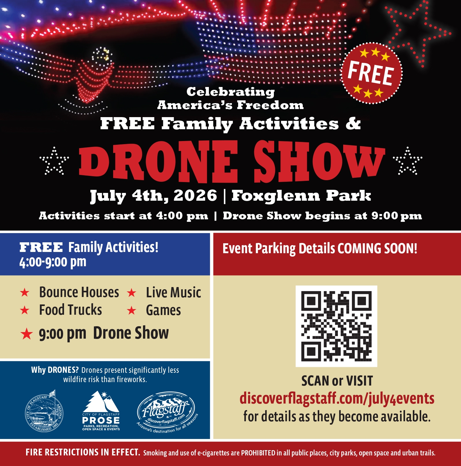
As evening approaches, the celebration shifts to Fox Glenn Park, where the City of Flagstaff hosts free family activities beginning at 4:00 p.m. Families can enjoy bounce houses, games, live entertainment, food trucks, and community activities throughout the afternoon and evening.
The highlight of the evening is Flagstaff's "Celebrating America's Freedom" Drone Show. Due to wildfire concerns and the city's commitment to protecting surrounding forests, Flagstaff has embraced drone technology as a spectacular alternative to traditional fireworks. Hundreds of synchronized drones create dazzling patriotic images and animations in the night sky, offering a safe and environmentally conscious celebration that has quickly become a local favorite. The show is scheduled to begin around 9:00 p.m. on July 4.
Flagstaff's location in Northern Arizona's high country creates a holiday experience unlike anywhere else in the state. Visitors can spend the morning watching a parade, enjoy local art and live music in the afternoon, hike among towering pines, and finish the day under a cool mountain sky illuminated by a cutting-edge drone show.
The city's emphasis on community, outdoor recreation, and environmental stewardship makes Flagstaff's Independence Day celebration both traditional and uniquely modern.
The Fourth of July is one of Flagstaff's busiest weekends of the year. Hotels, vacation rentals, and campgrounds often book well in advance. Visitors are encouraged to arrive early for downtown events, bring lawn chairs and sunscreen, and take advantage of the city's many restaurants, breweries, and outdoor attractions throughout the holiday weekend.
Whether you're escaping the desert heat or looking for a classic small-town Independence Day celebration, Flagstaff delivers a memorable Fourth of July experience that combines patriotic tradition with the natural beauty of Northern Arizona.

If you’re thinking about refreshing your home, even a few strategic color changes can make a dramatic impact. Whether you’re preparing your home for long-term enjoyment or positioning it for future resale, intentional color design adds both value and appeal. Here are three standout color combinations to consider in 2026, each with a unique personality and versatility suited for modern homes.

Why it works:
Clay and blush are gentle earth tones that create a sense of calm and comfort. When paired with the strong presence of matte black, the combination achieves a beautiful balance between softness and structure. The result is a palette that feels warm and contemporary at the same time.
Where to use it:
Why homeowners love it:
This palette feels timeless yet fresh, especially for those wanting a cozy home that remains upscale. For homeowners preparing for future sale, it’s a pleasant choice- appealing to many buyers without feeling generic. The combination is both personal and polished, which gives the home a sense of intentional design.

Why it works:
Navy is timeless and dependable, while sage introduces an uplifting natural element. Aged brass becomes the binding element, adding warmth, shine, and old-world charm. When combined, the palette feels elevated without becoming formal or restrictive.
Where to use it:
Why homeowners love it:
This palette adapts beautifully to both traditional and contemporary homes. Its rich, layered appearance gives spaces a tailored feel, which often enhances perceived value. Homeowners who prefer something more expressive than neutrals- but still timeless- find this combination especially appealing.

Why it works:
Mushroom offers a comforting foundation that works with virtually any style. Mist blue introduces a refreshing, airy quality without being too bold or too pastel. Warm gold accents bring life and depth to the palette, giving it a sense of refinement and warmth.
Where to use it:
Why homeowners love it:
This combination is ideal for anyone who wants a modern, serene home without leaning too heavily into cool tones. It feels fresh, clean, and harmonious. It’s also a flexible palette that photographs exceptionally well, which is helpful if you’re considering future marketing or listing preparation.
Bringing It All Together
Each of these three color combinations reflect the direction homeowners are gravitating toward in 2026: grounded comfort, natural sophistication, and refreshed simplicity. Whether you’re updating a single room or considering a whole-home design shift, these palettes offer both beauty and long-term appeal.
Thoughtful color choices also contribute meaningfully to your home’s value and livability. If you’re planning updates with a future move or investment goals in mind, partnering with an experienced, well-connected real estate professional can help you prioritize design choices that resonate widely while still feeling uniquely your own. A new year is the perfect time to experiment, refresh your space, and create a home that inspires you daily—and the right color palette is a simple, high-impact way to start.
Summer is just around the corner! But before vacations and celebrations and in light of our country's 250th anniversary, I wanted to check back with a newsletter I sent few years ago. The message is still so relevant, and the man is still very missed:
Each Memorial Day we pause to remember those who served in the military. This Memorial Day has been more poignant than most. A Vietnam Veteran, a close friend of our family, was laid to rest with full military honors on Friday at the cemetery at Camp Navajo. William (“Bill”) Cherry was larger than life serving in the Army for more than 25 years. During this time, Bill served many tours in Vietnam as an infantryman and an Army Ranger, Special Forces (82nd Airborne, 3rd Battalion). After numerous postings in the States and abroad, Bill’s last post was as Battalion Commander at the Navajo Army Depot (Camp Navajo) in Bellmont. He then went on to earn a PhD in political science and served again as a professor at NAU. His wife and family shared beautiful memories of a life lived in the service of others. Part of these memories were their “Top 10 Bill-isms”.
I’d like to share the top two:
#2 – “You live life between your ears.” We have little to no control of what happens outside of ourselves. However, we have absolute control over how we handle our own emotions and actions.
#1 – “There is only one thing better than having it good; having it good and knowing it.” Bill was certainly a philosopher. 
Memorial Day was not a sad day for Bill. It was a day of fond remembrance. Bill remained grounded in his Army roots. He was the commander of the American Legion, Mark Moore Post #3 (2007 – 2008). Bill volunteered for the Flagstaff International Relief Effort (FIRE), the MS Society, Friends of Flagstaff’s Future and often volunteered his time as a charity auctioneer for local organizations. He was a member of the American Legion riders, ABATE, and Veterans for Peace. Bill also completed the motorcycle Run for the Wall, a tribute for Vietnam Veterans. I have a feeling that if he had been longer on this earth, he would have volunteered at the new Arizona State Veteran Home in Flagstaff. Please check the link to see the most recent updates.
This Memorial Day please consider donating to organizations that assist veterans. A few are listed below and a quick internet search shows many more both local and nationwide.
If you or someone you love is active military or a veteran, please thank them for their service for me. If you have lost someone in active duty, please know your family is in my prayers.
In the June newsletter, we will get back to real estate as our market is heating up!
Blessings,
Kim
Where the Experts are - Serving Flagstaff and Northern Arizona since 1977
 |
|