Wayne McCormick
Broker/Owner
Realty Executives of Northern Arizona
A Quick 401k Breakdown:
Your 401k is a retirement plan where your money can grow tax-free. However, to avoid any monetary penalties, you can’t withdraw your money until you’re 59 1/2. You get to choose what percentage of each paycheck you want to invest in your retirement. The money is withdrawn from your paycheck pre-tax. Therefore, you won’t owe any tax money until you start to withdraw at retirement age. Withdrawing before then can lead to an early withdrawal penalty plus additional income taxes. However, there are some exceptions.
Borrowing from Your 401K
When borrowing from your 401K you don’t have an early withdrawal fee and you don’t have to pay income taxes on the money you withdrew. Think of this strategy as a loan from yourself, to yourself. Just like a regular loan, you will need to pay yourself back, plus interest. Usually, you will need to pay back your account within about five years, but this time frame can vary.
The consequence though, is that your repayment deposits don’t count as contributions – so you don’t get a tax break. When borrowing you can usually take out half of your vested account balance or $50,000. It depends on which has less money.
Pro Tip: Just because you’re borrowing from yourself doesn’t mean you’re not taking on debt. In the eyes of a lender, you may no longer qualify for certain mortgages or rates.
Withdrawing from Your 401K
If your 401k provider doesn’t allow borrowing from your 401K or you need more than $50,000, you will have to withdraw from your account. You will incur the 10% withdrawal fee and have to pay income taxes on top of that. Unlike borrowing, you don’t have to pay this money back.
If you are under the age of 59 1/2, you are allowed one “hardship” withdrawal in certain circumstances such as buying your first home. With a hardship withdrawal, you are allowed to take out $10,000 and avoid the 10% penalty fee, but you still have to pay income taxes.
Being the longest running real estate brokerage in northern Arizona is carrying a torch of responsibility that Realty Executives of Flagstaff is proud to carry. This year, they are looking at two big milestones in their history: reaching 47 years of business along with the 30th anniversary celebration of their two veteran brokers, Wayne McCormick and Gary Nelson.

Forty-seven years does not seem like a long time to many, but in the real estate industry, it is quite a feat because in that same forty-seven years, many other real estate brokerages came and went. “With constantly shifting real estate markets, there are very few real estate offices that are built to last,” says McCormick, who owns Realty Executives of Flagstaff along with his wife, Debra. “Our commitment to the communities we serve is the difference.”
“I would add that being local is really what sets us apart from our competition,” says Delegated Broker Gary Nelson. “With many real estate brokerages from other parts of Arizona, the dedication to community just isn’t there.”
By their own estimation, Realty Executives of Flagstaff has dedicated hundreds of thousands of dollars over the years to local charities, non-profits, and youth activities. “We decided many years ago that our commitment to the people and nonprofits in our communities was the most important aspect of truly considering ourselves local," added McCormick. "The Realtors in our office have fully embraced that and do whatever they can to give back."
"We have such a great group of Realtors here," adds Nelson. “Each of them is a part of the community in their own way and has embraced the idea of ‘giving back.’ We have board members, committee volunteers, work horses, donors and Realtors that believe in a cause or event that is near and dear to their heart.”
Wayne McCormick and Gary Nelson are not only celebrating the forty-seven years that their brokerage has been running but also thirty years in the industry together. “We actually knew each other back in Boy Scouts here in Flagstaff, even though there were a few years between us,” says McCormick. “But we also started the same year in real estate and went through ‘orientation’ at the Northern Arizona Association of Realtors together. We are the last two left from 1994. And it was pretty much destiny that we would end up being partners like we are. Fifteen years ago, when I took over the brokerage that my father, Dave McCormick, founded, I needed someone to help me stay the course and commit to the community. Gary was that person, and we have never looked back.”
In September, Realty Executives of Flagstaff will throw a party – a big party! And it is not for themselves, but for the Realtors, other business people, and clients that have helped Wayne and Gary get to this landmark. “We have been in both competition and cooperation with thousands of Realtors in Flagstaff over the years,” says Debra McCormick. “They helped us get to where we are. Along with the lenders, escrow companies, contractors, and other professionals that worked with us to make this City a better place.”
“We throw a client appreciation party on the morning of the Fourth of July for about six hundred of our clients each year,” adds Debra. “Let’s see if we can get 600 of our fellow Realtors and industry professionals to help us celebrate in September! Even bigger, yet, will be our party in three years when we celebrate 50!”
Arizona Daily Sun, Shop Flagstaff (Local) Edition, June 29, 2024
If you survey 100 agents in Arizona asking them to rate on a scale of 1 to 5, how much they enjoy representing homes with solar, it would probably show almost all 1’s. For that reason, many agents avoid solar altogether while others may have had only occasional transactions. Why does there seem to be such a low opinion among agents for this renewable energy source for homeowners?
It boils down to the fact that many have had negative experiences and lost money, clients, and buyers due to not understanding solar and its complexities.
The truth however, is that solar panels are an amazing technology that has the capability of producing electricity for at least 50 years. With a little bit of understanding of the basics of solar, homes with solar don’t have to be such daunting transactions.
The 3 Methods of Solar Ownership
There are three methods a homeowner can choose with their solar: it can be owned outright, owned with a loan, or leased. For a real estate agent, each one of these presents its own unique challenges. Some of those challenges unfortunately, due to misrepresentation on the part of the agent, have ended up in court.
Ownership Method #1 – Owned Solar
Challenge #1:
Listing the home openly and properly as a solar home so you don’t lose your client.
Solution #1:
Market the home as a solar home and showcase the solar as an added value feature in order to help sellers recoup at least some of their investment into solar.
Ownership Method #2 – Solar With a Loan
Challenge #2:
Solar loans require a negotiation in escrow to determine if the loan will be paid off or assumed by the buyer.
Solution #2:
When marketing a home, demonstrate the value with the proper solar value documentation. A solar loan is always part of the negotiation of the purchase price. A fundamental understanding of the value of the solar system empowers a better negotiation so that both the buyer and seller walk away happy. The two outcomes are to either pay off the solar loan or transfer it to the buyer.
Ownership Method #3 – Leased Solar
Challenge #3:
Getting a buyer on board with assuming a 20-year contract. There is typically an increase built into it each year.
Solution #3:
This challenge has two solutions. The first option is to help the home buyer understand how much the solar is going to save them each month on electricity and get the lease contract transferred into their name. The second, and better option is to help the buyer buy out the solar system from the lease company, as part of the home purchase. This will add value later whenever they decide to sell.
To understand those three challenges and create buyer confidence in the solar on a home, it’s important to know that any given system will have between 1 and 6 contracts connecting the solar system to the home and its owner. These also need to be navigated in the real estate transaction.
Solar contracts that agents need to navigate:
You can both minimize your liability and help the buyer of a solar home feel confident by learning about and understanding these contracts. To better serve your clients with solar homes, be sure to explore these contracts and the best practices associated with them.
Buying a home is usually the largest purchase and financial commitment most people make in a lifetime. The process of finding and buying a home is both exhausting and complicated. For those reasons, you should find an experienced, local REALTOR® like Wayne McCormick, Broker/Owner at Realty Executives of Flagstaff, to guide you through the process, represent only you, and ensure your best interests are protected from start to finish. Here’s why Wayne is your best choice.
Typically, there are two REALTORS® involved in a real estate transaction.
Both agents are legally bound to represent only the interests of their clients, the buyers and sellers.
Some buyers make the mistake of contacting the listing agent and asking them to show them a home they are interested in. Buyers often think they can “get a better deal” if they work with the seller’s agent.
There are several reasons why that can be a costly mistake.
If you do choose to work with the seller’s agent, your choices of being fully represented are nonexistent. A seller’s agent can help you buy his seller client’s house with these agency choices:
1. Seller Agency – “The licensee has the duty to represent the seller’s best interests in the transaction.” You are not represented.
2. Single Agency – For all practical purposes, the same as a Seller Agency. You are still not represented.
3. Disclosed Dual Agency – A disclosed dual agent is a licensee acting for both the seller and the buyer in the same transaction and with the knowledge and written consent of both parties. The licensee cannot advocate on behalf of one client over the other. You are not fully represented.
None of these choices allow a licensee to fully represent you, the buyer.
Here Are Some Common Pitfalls When A Home Buyer Works Directly With The Listing Agent.
Buyer Representation
When Working With A Buyer’s Agent
After review of the Buyer-Broker information, when both parties come to an agreement, here are some terms and obligations binding both parties under the agreement:
Broker’s Obligation
Buyer’s Obligation
Compensation
For these services, the broker will be paid a fee at closing equal to the amount listed in MLS for the cooperating broker’s payout. For properties not listed with a broker, we will seek compensation from the seller, but the buyer agrees to fund any deficiency up to 3% of the purchase price. This compensation agreement shall apply to all properties that the broker submits for the buyer during the term of this agreement for a period of 120 days beyond the termination date.
Termination
This agreement terminates at 11:59pm on the last day of the term, unless, before that time, the buyer has entered into a contract to purchase property covered by this agreement or if either party notifies the other in writing that they wish to terminate this agreement within 7 days’ notice. If the buyer is under contract to purchase a property, then this agreement will continue if effect until closing.
Mediation
If a dispute arises concerning this agreement and con not be resolved through good faith negotiations, then both parties agree to submit the dispute to mediation. If mediation becomes necessary, the parties will choose a mutually acceptable mediator and will share equally in cost.
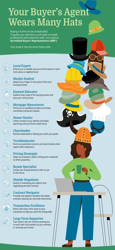
A Buyer’s Agent’s job is to advise you through every step of the Homebuying Process.
In summary:
What Are Some Specific Things My Buyer’s Agent Can Do For Me?
Glad you asked, here are just a few from a very long list:
Some ask; “How Much Does A Buyer’s Agent Cost?” But a better question might be: How Much Does NOT Having A Buyer’s Agent Cost?”
There is a cost to hiring someone to act solely on your behalf. First of all, real estate commissions are fully negotiable between the licensee and their proposed client.
Often the seller’s agent has already agreed to share the fee the seller is paying them with the agent that brings the buyer. In any event, you will know exactly what amount you will be responsible for before you sign anything.
Finally, you should make sure the real estate licensee you hire to be your buyer’s agent is a REALTOR® which means they are members of the National Association of REALTORS® (NAR) and have pledged to abide by their strict Code of Ethics. Not all real estate licensees are REALTORS®.
Contact me with any questions!
928-526-7300